


")


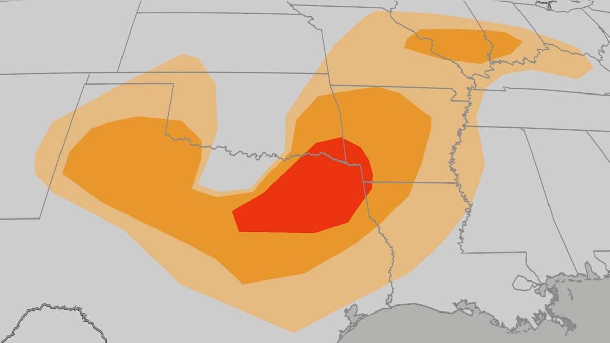
Severe weather will continue to plague the Southern Plains Wednesday, including threat of tornadoes, hail and damaging winds. If that wasn’t enough, there is also a concern for dangerous flash flooding from northern Texas into Oklahoma and the Ozarks.
What We Are Tracking Now
Clusters of thunderstorms, some of which are severe, along with heavy rain, are sweeping through the South and lower Midwest. You can see the latest radar and any watches and/or warnings in the map below.
The heavy rain prompted a few road closures around the Dallas-Ft. Worth Metroplex late Wednesday morning. A wind gust to 68 mph was clocked in Collin County near Celina. Flooding prompted evacuations Wednesday in Lexington, Oklahoma, about 30 miles south-southeast of Oklahoma City. About 20 river gauges are either reporting or forecast to be at moderate or major flood stage in Oklahoma and northern Texas.
Oklahoma City (over 12.5 inches), Tulsa (over 11 inches) and Wichita Falls, Texas (over 10 inches) have each set their all-time wettest Aprils, so far. Oklahoma City picked up about 3.5 times their April average precipitation this month.
For details on yesterday’s widespread severe weather, scroll to the bottom of this article.
Current Radar, Watches And Warnings
Severe Weather Forecast
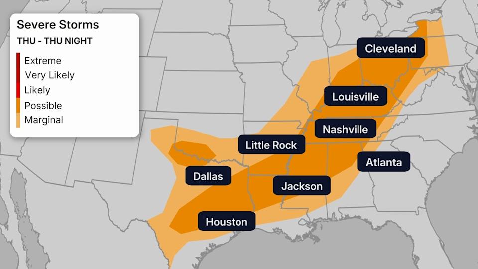
-Thursday: The potential for severe weather should decrease as the storm system pushes east. That said, a broad area from the eastern Great Lakes southward to the Ohio Valley, lower-Mississippi Valley and eastern Texas could see some instances of damaging winds, hail and a low-end tornado threat.
-Stay Safe: Be sure to know where you’ll go in case a severe thunderstorm or tornado warning is issued, whether you live in a home, apartment, manufactured home, are at work or driving. You need to have not just one, but a few ways of receiving watches and warnings, including NOAA Weather Radio, an alert from your smartphone, and local media sources such as radio or TV.
See this link for additional information on these tips, plus others that will help plan for severe weather now and in the future.

Thursday’s Severe Weather Threat
Flash Flood Threat
-Flood Alerts In Effect: The National Weather Service has issued flood watches from northern Texas into Oklahoma, western Arkansas, northwestern Louisiana, southeast Kansas and parts of southern Missouri. This means flooding is possible in these areas.
-What To Expect: Bouts of heavy rain through Thursday could trigger flash flooding, including in some of the same areas that have been soaked lately.
-Stay Safe: Be sure to avoid driving through floodwaters if you are traveling through this region. It may be tough to tell how deep the water is when you approach a flooded section of roadway, especially at night, so never try to proceed and instead “Turn around. Don’t drown,” as the National Weather Service says. Entering a flooded area can allow water to enter your vehicle in a manner of minutes, even seconds.
(MORE: Never Drive Through A Flooded Road)
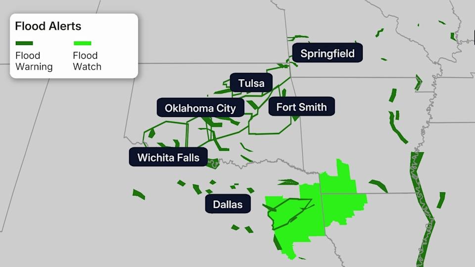
Flood Alerts
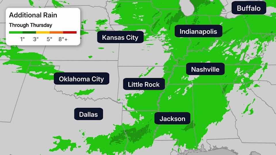
Additional Rainfall Forecast Through Thursday
Severe Weather Recap Tuesday
Tuesday’s storms produced more than 350 reports of severe weather from Texas to Pennsylvania and New York, mainly in the form damaging wind gusts. Hundreds of thousands of homes and businesses lost power in Pennsylvania and a 106 mph gust was clocked in Seymour, Texas.
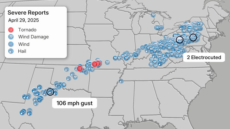
Roof damage was reported in Collinsville, Oklahoma, north of Tulsa from a brief EF1 tornado just after 7 a.m. Power poles and trees were downed in Miami, and wind damage was reported at the Delaware County Fairgrounds in Jay.
In Missouri, a large truck stop sign was downed west of Springfield, and 91 mph winds were measured at Springfield-Branson Airport where a maintenance facility and plane in storage were damaged, KY3 TV reported. A gas station was heavily damaged just west of the airport and a home reportedly “half collapsed” at a golf course on the west side of Springfield, according to an amateur radio operator and the National Weather Service. Damage including a “vehicle wrapped up in power lines” was also reported in Aurora from what was a brief EF1 tornado. South of Neosho in Newton County, part of a barn was blocking Interstate 49 from what may have been a tornado.
The reports of damaging wind gusts extended from Missouri to Pennsylvania and Upstate New York by Tuesday evening. A tree fell and injured a driver in a car in Greene County, Pennsylvania. Some straight-line wind damage east of Pittsburgh was consistent with 90 to 95 mph wind gusts, according to the National Weather Service.
Damage in More than 700,000 customers lost power in Pennsylvania, Ohio, New York, Michigan and West Virginia. Pittsburgh’s 71 mph wind gust was the third strongest gust on record at Pittsburgh International Airport, according to the National Weather Service.
(IMPACTS: Storms Turned Deadly In Pennsylvania)
Read the full article here


