
Widespread severe thunderstorms are expected to develop Sunday in the Midwest and South, then spread to the East Coast on Monday as March comes to a close.
The areas included in this severe threat are some of the same locations impacted by a major severe weather outbreak two weeks ago.
(MORE: How To Prepare For Severe Weather | Track The Threats With Our Maps Tracker)
Timing
The new storm system has fired up a few thunderstorms, but thunderstorms will become more widespread as the day progresses.
Tornado watches have been issued from Arkansas to southern Michigan.
Early Sunday, a wind gust of 85 mph was recorded in Baxter Springs, Kansas, and roof damage and trees down were reported. Joplin, Missouri, measured a wind gust of 79 mph. Hail up to 2.5 inches in diameter fell near Bridge Creek and Amber, Oklahoma.
Here’s where rain and thunderstorms are occurring now:
Current Radar
Here’s the latest on what to expect over the next few days:
-Sunday-Sunday Night: Widespread severe storms will develop Sunday afternoon and last into the overnight hours from eastern Texas to the southern Great Lakes, including portions of the Mississippi, Ohio and Tennessee valleys.
Very large hail, damaging winds and strong tornadoes (EF2 or higher damage) are expected, especially in the red-shaded areas below, according to NOAA’s Storm Prediction Center. That includes Indianapolis, Indiana; Little Rock, Arkansas; Louisville, Kentucky; and Memphis and Nashville, Tennessee.
A few supercells or thunderstorm clusters may develop bringing the risk of large hail and the potential for a couple of tornadoes Sunday afternoon before thunderstorms transition to a line of thunderstorms late Sunday evening into early Monday morning. The damaging wind gust risk will increase overnight.
The potential for severe weather will likely erupt on the western side of the threat area shown below first, then spread eastward from there. That means severe weather will be a concern in the evening or overnight hours in some locations, especially in areas near and east of the Mississippi River, so be sure to have a way to receive alerts to wake you up at night.
(More: What The Storm Prediction Center’s Thunderstorm Outlook Means)
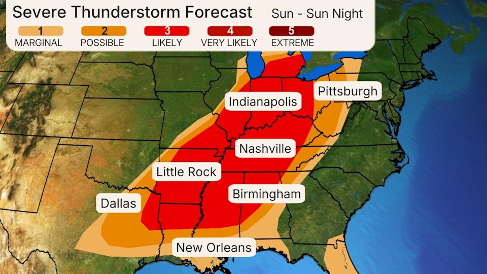
Sunday-Sunday Night’s Severe Weather Forecast
-Monday: Severe weather will continue ahead of a cold front from the northern Gulf Coast into the Southeast, the mid-Atlantic and Northeast, possibly including Atlanta, Georgia; Charlotte and Raleigh, North Carolina; Jacksonville, Florida; Columbia, South Carolina; and Washington, D.C.
Some severe weather will be ongoing in the morning hours, especially on the western edge of the threat area shown below. Through the day and into the early evening, those storms could intensify and new ones might form ahead of the cold front while spreading to the East Coast.
Wind damage is the biggest threat from any severe storms that push through the mid-Atlantic and Northeast. In the Southeast, from the Carolinas to Georgia and the Gulf Coast, the storms could produce wind damage, large hail and a tornado threat. The best chance for a few tornadoes stretches from southern Alabama into Virginia, as shown in the red area below.
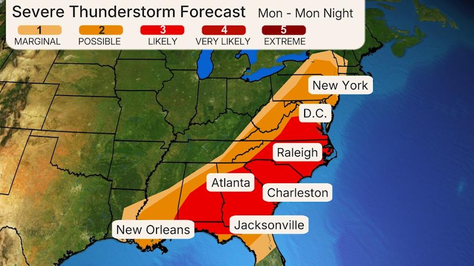
Monday’s Severe Weather Forecast
As we begin April, another low pressure system will bring the threat of severe weather to parts of the Midwest, Ohio Valley and South midweek. This next round on Wednesday may evolve into “a widespread and potentially substantial outbreak of severe weather,” according to NOAA’s Storm Prediction Center’s outlook on Sunday morning.
A Springtime Setup
The setup supporting this multiday severe weather threat is familiar for March and the rest of spring, with a sharp southward plunge of the jet stream swinging out of the West toward the central and eastern states.
A strong low-pressure system with embedded strong wind shear will sweep from Kansas to New York over the weekend, helping pull a moisture surge northward from the Gulf. These will lead as potential drivers of severe weather, including supercells.
(192-hours: Further beef up your forecast with our detailed, hour-by-hour breakdown for the next 8 days – only available on our Premium Pro experience.)

Sara Tonks is a content meteorologist with weather.com and has a bachelor’s and a master’s degree from Georgia Tech in Earth and Atmospheric Sciences along with a master’s degree from Unity Environmental University in Marine Science.
Read the full article here